BOUNDARIES
by Jon Maynard FRICS
leading Chartered Land Surveyor who has recognised an increasing need
amongst property owners in England and Wales for help with problems relating
to their boundaries.
WHOSE FENCE IS IT ?
| The only sure way of knowing who owns the physical feature used as a property boundary is if its ownership is stated in your title certificate or deeds of conveyance. It may be expressed in writing, but it is sometimes shown on the plan instead by a T-mark: this takes the form of a letter "T", repeated around the edge of the property, with the base of the "T" against the boundary and the whole of the "T" inside the property that owns the fence. If neither owner can find such evidence, then you cannot tell who owns the fence or is liable for its repair. | |
It is sometimes possible to infer who is responsible for a fence by establishing the pattern of fence ownership along the same side of the street.
What you should do
When the time comes to replace a decaying fence whose owner cannot
be definitely identified, he who is willing to pay for the repairs is the
one who dictates what the new fence will look like (within any constraints
of planning regulations or restrictive covenants).
HOW GOOD IS THE MAP ?
Most land registration in England and Wales is based on a 1:1250 scale Ordnance Survey map, on which the thickness of the line on the map is equivalent to a line 25 cms (10 inches) wide on the ground. In rural areas the mapping is at 1:2500 scale, where the line on the map is 50 cms (20 inches) wide on the ground.
Some land registration is based on maps enlarged from 1:2500 to 1:1250 scale, where the line on the map is also 50 cms (20 inches) wide on the ground).
Compare those line thicknesses with the average larch-lap panel fence, supported on fence posts only 7.5 cms (3 inches) thick!
According to Ordnance Survey's own map specifications, in some circumstances the general accuracy of the map can add up to a further 2 metres (6 ft 6 ins) imprecision in the positions of mapped features.
The map identifies the physical feature to which the property boundary is tied, rather than precisely locating the exact position of the legal boundary.
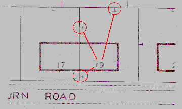
Complications can arise because Ordnance Survey maps use the same line
symbol for a wall, fence, hedge, bank or ditch, making it sometimes difficult
to know just what the line represents. Worse, if two linear features
are parallel and very close
there is sometimes not enough room on the map to show both of them:
it is sometimes unclear as to which is shown.
What you should do
If you have difficulty in relating the map to what is on the ground,
ask HM Land Registry for their opinion. If that does not resolve the matter,
consult a chartered land surveyor (e-mail me) .
Ordnance Survey have published an accuracy statement for their large scale maps. You can find it at http://www.ordnancesurvey.co.uk/productpages/landline/positional-background.htm
Because the accuracy depends on scale and method of survey, you will
need to find out these details for the Ordnance Survey map of the
area covering your property. Go to the Ordnance Survey web site and click
on "Tile selector" and use one of the methods offered
in order to find the "thumbnail" map of your area. The page presented will
give the details you need in order to interpret the accuracy statement.
LOCATING IT TO THE NEAREST MILLIMETRE
You most probably cannot locate a boundary that precisely, both because of the limitations of the Ordnance Survey map and because of the "General Boundaries" rule.
The legal boundary dividing two properties is an invisible line, having no thickness, and it is unlikely to be precisely identified either on the ground or in the deeds or title documents.
The physical boundary is a physical feature, such as a hedge or fence, that may have been intended to follow the legal boundary, but the precise extent of land ownership may not be entirely clear from the position of the physical boundary (is it in the middle, or on one side or the other of the hedge?).
Because land registration normally takes place long after the physical boundaries have been established, HM Land Registry filed plans are prepared under the General Boundaries rule, which states "...the exact line of the boundary will be undetermined - as, for instance, whether it includes a hedge, wall or ditch, or runs along the centre of a wall or fence, or its inner or outer face, or how far it runs within or beyond it; or whether or not the land registered includes the whole or any portion of an adjoining road or stream".
So, you don't know exactly where the legal boundary lies in relation to the line on the map, and you have seen above that you cannot put your absolute trust in the position in which the line is shown on the map.
What you should do
You should try to agree a compromise with your neighbour because, if
you are arguing over a strip of land that is only inches wide, it is quite
possible that no amount of professional advice will determine the true
position of the legal boundary.
If you are unable to reach such a compromise, then professional advice (e-mail me)will provide a third, and impartial, opinion as to the position of the boundary. It would be wise to accept this as the basis of a settlement with your neighbour: thealternative is a very expensive court case.
HOW GOOD IS THE HMLR FILED PLAN ?
There are four things that affect the accuracy of the information shown on an HM Land Registry filed plan:
1. The accuracy of the underlying Ordnance Survey map (see above);
2. The possibility that the General Boundaries Rule may cast further
doubt on the map positions;
3. The quality of the information supplied to HM Land Registry;
4. The accuracy with which HM Land Registry have interpreted the information
whilst applying their red edging to the map.
I have seen filed plans that:
a. leave a gap between properties (where you would expect no gap to
exist);
b. show an overlap between properties (which cannot physically happen);
c. show a property as extending only to the edge of a road even though
the conveyance stated that it extended to the centre of the road.
I have also seen a filed plan that faithfully reproduced the conveyance plan, which was in turn based upon the plan the vendor used to advertise the property for sale. The sale plan (and the conveyance plan) carried the warning, "This plan is published for the convenience of Purchasers only. Its accuracy is not guaranteed". I did a detailed survey of the physical boundaries more than 20 years after the sale in question and, not surprisingly, found them to be up to 4.25 metres (14 feet) away from the positions shown on the conveyance plan.
To be fair, these kinds of problems with filed plans are the exception rather than the rule, but in some cases they are at the root of the boundary problem.
What you should do
Check the filed plan for your property with any other relevant documents
you can find. These include the HMLR register entry for your property,
old conveyance deeds and conveyance plans for your property, and similar
documents relating to neighbouring properties.
If you are unable to determine where your boundary is, or are unable
to persuade your neighbour to agree to your understanding of where the
boundary is, then you will need professional advice (e-mail me) .
SO, WHERE IS THE BOUNDARY?
| If you have found the evidence to prove that you are responsible for
the boundary in question then you can usually assume that the legal boundary
(the line of no thickness) is to be found on the outer face of the physical
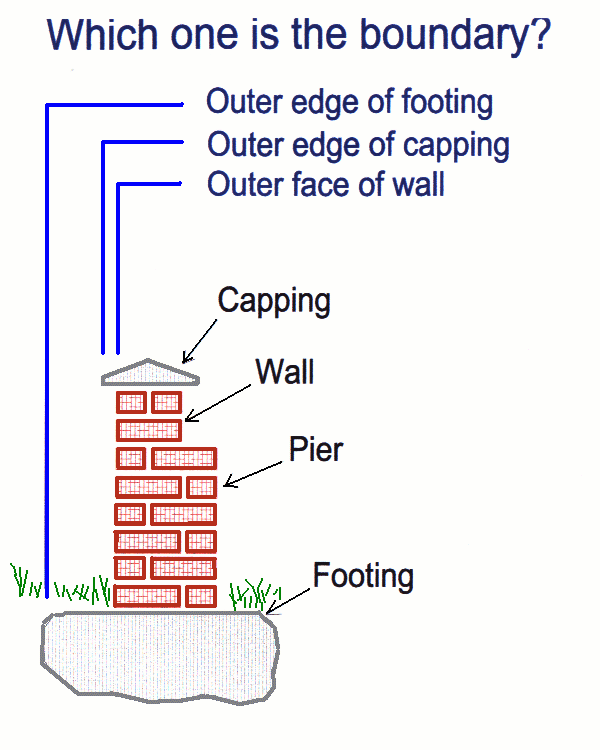
boundary feature. But life is not always that simple. Consider the cross
section of a typical, brick-built garden wall, right. Just where is the
boundary? [I am not telling you the answer, because it will vary from property
to property and could be any or none of the options offered.]
If the boundary follows the side of a building, then the conveyance may include an easement to allow the eaves and gutters to overhang, and the footings to encroach beneath, the neighbour's land. In this case you can be sure that the outer face of the wall of the building is where the legal boundary is to be found. But if there is no such easement, then where is the boundary? Fences, at first sight, are quite straightforward. But there are many cases where the owner responsible for a particular cannot be identified from a title certificate or a conveyance deed. And then there are cases where a fence that was intended merely to control livestock (rural situations) or to contain dogs within their owner's garden (urban) might be mistaken for a boundary fence. There are also cases where fences that appear to define front boundaries are in fact placed back from the boundary because of a restrictive covenant preventing any structures within a certain distance of the edge of the road. If you are certain that the fence is in fact on the boundary, and you can identify the owner of the fence and confirm that he is the party responsible for that boundary, then the legal boundary will usually be on the outer face of the fence. |
 |
Hedges create many problems for someone trying to locate a boundary. Unlike walls and fences which, once erected, do not change their thickness, a hedge grows every year, and is usally trimmed by its owner or by the people living either side of it. Its thickness is therefore constantly changing. The only constant about a hedge is the "root of hedge" - a line drawn to join up points at which the plant stems rise from the ground. It would be unusual for the "root of hedge" to form a boundary unless the hedge was specifically the joint responsibility of both neighbours.
Hedges are often found close to other features which more usually define the boundary. It is common for a hedge to be grown behind a dwarf wall on the frontage of an urban property, or beside a wire fence separating two rear gardens, but again be sure that the fence is not there merely to control dogs.
Some properties are bounded by rivers, coastlines, clifftops, lake shores, all of which are features that are prone to natural movement, causing further complications for the landowner.