by Mary M. Root
 The
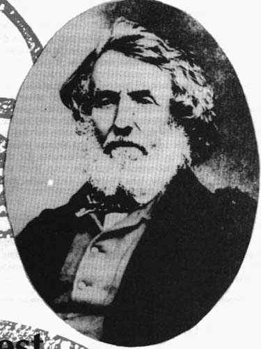
highest mountain in the world is named for a surveyor, Colonel Sir George
Everest. It is a fitting tribute to the man who, for more than twenty-five
years and despite numerous hardships, prevailed in surveying the longest
are-of-the-meridian ever accomplished at the time. The Great Trigonometrical
Survey India, begun at Cape Comorin in 1806 by William Lambton, would then
run almost 2,400 kilometers north to the Himalayas, extending over 20 along
the meridian. During this tremendous undertaking, Everest was relentless
in his pursuit of accuracy. To that end, he made countless adaptations
to the surveying equipment, methods, and mathematics in order to minimize
problems specific to the Great Survey: immense size and scope, the
terrain, weather conditions, and the desired accuracy.
The
highest mountain in the world is named for a surveyor, Colonel Sir George
Everest. It is a fitting tribute to the man who, for more than twenty-five
years and despite numerous hardships, prevailed in surveying the longest
are-of-the-meridian ever accomplished at the time. The Great Trigonometrical
Survey India, begun at Cape Comorin in 1806 by William Lambton, would then
run almost 2,400 kilometers north to the Himalayas, extending over 20 along
the meridian. During this tremendous undertaking, Everest was relentless
in his pursuit of accuracy. To that end, he made countless adaptations
to the surveying equipment, methods, and mathematics in order to minimize
problems specific to the Great Survey: immense size and scope, the
terrain, weather conditions, and the desired accuracy.
When Everest "inherited" the position in 1823, the equipment originally employed by Lambton consisted of one 36" theodolite manufactured by London instrument maker Cary, a zenith sector by Jesse Ramsden, a Ramsden 100 foot steel chain, and a chronometer. The Cary theodolite, weighing over one thousand pounds, had been damaged in two separate mishaps, and was badly in need of repair. The micrometer screw on the zenith sector was worn out, and the steel chain had not been calibrated in twenty-five years. To further complicate matters, Everest became so dangerously ill that he could not carry on with the Survey, and work was suspended.
England was the solution to these problems. In November of 1825, Everest returned to England, bringing with him the mathematical observations and calculations for the Great Arc thus far. For the next five years he worked on improvements for the survey and compiled an account of the work achieved between the parallels of 18 degrees 03' and 24 degrees 07'. Everest spent a great deal of time in the workshop of instrument-makers Troughton and Simms, where an additional 36" theodolite, a new zenith sector, and six small theodolites were under construction. Of the last, Everest wrote: "I have devoted some consideration to the improvement of the common theodolite which is both cumbersome and more expensive than need be and after frequent examination of all the best devices I could meet with in the shape of the various makers in London, Mr. Simms has at my suggestion designed an instrument which contains all the useful parts of the old construction, is quite free from superfluous apparatus and is cheaper by one-fourth...The model has only a 5 inch diameter but the principle is so perfectly applicable to all instruments for secondary triangles that I should respectfully recommend the propriety of adopting this as the Honorable East India Company's form for all small theodolites not exceeding 12 inches diameter and preserving on all future occasions the strictest uniformity."
The next issue Everest addressed was the measuring of distances. He learned of Col. Colby's work with compensating bars on the Irish Survey, and visited him there in 1829. Being very much impressed with Colby's system, he acquired a double set of six bars for the Great Trigonometrical Survey, and practiced with them at Greenwich.
At the same time, Everest produced a clever document which summarized the repair and replacement needs of the Survey, showing that the most cost-effective solution was to have an instrument maker placed in India. His request was granted, and Henry Barrow was appointed to the job. Later, in India, it was Barrow who laboriously repaired the damaged Cary theodolite, earning his praise from Everest: "I must do that artist (Barrow) the justice to say that for excellence of workmanship, accuracy of division, steadiness, regularity, and glibness of motion, and the general neatness, elegance and nice fitting of all its parts, not only were my expectations exceeded but I really think it is as a whole as unrivalled in the world as it is unique."
In June of 1830, George Everest returned to India, this time as Surveyor General, in addition to his post as superintendent of the Great Trigonometrical Survey. During the first year he spent little time on field work, as he organized general mapping surveys. Everest's first work on the Arc was to create a baseline near Dehra Dun using the Colby compensating bars. The 39,183.783 foot baseline was meticulously surveyed, using every precaution to safeguard its accuracy. He then connected the Dehra Dun baseline to the Sironj baseline, a distance of over 400 miles, using a triangulation gridiron. This was across a vast plain, which necessitated the construction of masonry towers, designed by Everest, most of them 50 feet high. The great theodolite was then hoisted to the top, and Everest performed and recorded the observations. By day, heliotropes were placed on distant points, reflecting bright flashes of sunlight towards the survey towers. On days when refraction became a problem, observations were taken at night, using an Indian version of the reverberatory lamp which could be seen for thirty miles, and sometimes by using cylindrical blue lights whose visible range could exceed fifty miles. Transportation was interesting; a typical foray included 4 elephants for the tiger-wary principals, 30 horses for the military officers, and 42 camels for supplies and equipment. The 700 or so laborers traveled on foot. Progress was steady; by May of 1836 half of the gap between Sironj and Dehra Dun had been completed, and the rest was completed the following season.
Everest next turned his attention to astronomical observations throughout the arc of meridian, especially at Kalianpur (24 degrees 07'). Unfortunately, ill health prevented him from completing this task, so it was Andrew Waugh who stepped in to finish the job, including re-measuring the Bidar baseline with the Colby compensating bars. The subsequent error of closure between the observed and computed length of the Bidar base, after 425 miles and 85 triangles from Sironj, was 0.36 feet in a line length of 41,578 feet.
By 1841, twenty-three years had passed from the time Everest had first begun work on the Great Arc. It would take him two more years to complete the computations, and compile the results before he retired and returned to England.
In 1848, he was awarded high honors by the Royal Astronomical Society. In making the presentation, Sir John Herschel said: 'The Great Meridianal Arc of India is a trophy of which any nation, or any government of the world would have reason to be proud, and will be one of the most enduring monuments of their power and enlightened regard for the progress of human knowledge."
POSTSCRIPT:
It is not known whether or
not George Everest ever laid his eyes on the great mountain that bears
his name, but his triangulation network was extended and used to locate
the summit by Andrew Waugh, Everest's successor as Surveyor General in
India. Waugh's admiration of Everest's achievements led to the naming
of "Peak XV" in the Himalayas. After its discovery by his team, Waugh,
wrote: "...here is a mountain most probably the highest in the world without
any local name that I can discover...", so he proposed "...to perpetuate
the memory of that illustrious master of geographical research...Everest."