Glossary of Surveying Terms
-
Accuracy Ratio or
Error Ratio
-
The error ratio is a means of expressing the magnitude of the error of
the survey in relation to the distance traversed by the survey. Intuitively,
a unit of error is of greater importance in a short traverse than in a
longer traverse.
-
The error ratio is expressed as the quotient of the absolute value of the
error and the distance traversed. Always give the value with "1" in the
numerator.
-
-
The permissible error ratio
depends on the accuracy required for the survey. Ordinary taping
generally refers to work for which the error ratio does not exceed 1/5000.
An accuracy ratio of 1/3000 may be allowed for rougher work, but there
is very little additional care needed in the procedures to attain the 1/5000
level. An accuracy ratio of 1/10,000 can be achieved by paying careful
attention to details.
-
Add Tape
-
An add tape has an additional major division at the head, beyond
the zero mark of the tape, which is subdivided into finer graduations,
usually in tenths of a foot (or meter), sometimes in hundredths. The use
of this tape requires that the minor reading be added to the major division
reading.
-

-
Some tapes have minor divisions at both the head and tail.
-
Adjustments
-
Since all real measurements are imperfect, some amount of error will accumulate
in the course of a survey. That error can be logically distributed throughout
the survey by various adjustment procedures (i.e., manipulation of the
data to produce a more logical result). Adjustments can and should be done
with any set of measurements for which error can be assessed.
-
Adjustment procedures do not correct the errors in the measurements.
They simply produce a set of data that is self-consistent (e.g., the starting
and ending points of a closed-loop leveling circuit have the same elevation
- which is physical reality). The adjusted values are not necessarily true
- they are just likely to be closer to the true values than the original
measurements.
-
Azimuth
-
The angle to a line of sight, measured clockwise from (usually) a north
meridian.
-
Backsight
-
A backsight is a reading taken on a position of known coordinate(s).
Since a survey progresses from a point of known position to points of unknown
position, a backsight is a reading looking "backward" along the line of
progress.
-
The first reading of almost any survey job should be a backsight onto a
fixed point of reference, usually a benchmark
of some sort.
-
(Compare to foresight).
-
Baseline
-
A baseline is a line used for reference in a survey job. It is often a
centerline or a street line. A baseline is not necessarily straight; e.g.,
the centerline of a street or pipeline will often curve. The important
aspect is that the baseline can be precisely located, then used for referencing
other measurements on the job site.
-
Selection of a baseline is entirely arbitrary. However, judicious selection
can make the rest of the job much easier.
-
Bearings
-
Bearings are used to indicate angular orientation with respect to the earth.
Bearings consist of three components:
-
The cardinal direction of the nearest end of the meridian (N or
S);
-
The angle measured from the nearest end of the meridian;
-
The cardinal point indicating the direction of deflection from the meridian
(E or W).
-
The angular measure is always within the range of 0-90 degrees.
-
Benchmarks
-
A benchmark (BM) is permanent marker (usually a bronze disk) at
a point of determined location (elevation and possibly horizontal coordinates).
In a less formal sense, it is a point of fixed location (such as a mark
on a bridge abutment, a foundation, or a rock face). It can be used as
a reference point for surveys in its locality. Descriptions of benchmark
locations and their elevations are published by government agencies.
-
A temporary benchmark (TBM) is a point of fixed location that is
used as a reference for a short-duration project. Its elevation may or
may not be determined with respect to a larger coordinate system. A TBM
could be something like a nail in a tree or fencepost, a mark on a curb,
or a sturdy stake driven in an out-of-the-way area of a project site.
-
Booking Values
-
Booking simply means "entering the field data in the field book".
A format appropriate for the type of survey should be followed to make
interpretation and retrieval easy.
-
Breakpoints
-
A breakpoint is a point where a change in some parameter of interest
occurs. In surveying, breakpoints are usually associated with changes in
slope. A profile survey which records only breakpoint stations can have
equivalent (or even better) information to a survey which records a regularly
spaced set of stations, but with fewer entries (and less time in the field).
-
Control Points
-
Control Points are fixed points of known coordinates. Such information
can give only elevation or can include all coordinates. Control points
are determined by high-accuracy surveys.
-
In a less rigorous sense, control points for a construction project can
be established conveniently around the project area using high-accuracy
procedures. Such points would then be used throughout the project for referencing
subsequent survey work, such as locating foundations, pipes, etc.
-
Cut Tape
-
A cut tape has the last major division at the head subdivided into
finer graduations, usually in tenths of a foot (or meter), sometimes in
hundredths. The use of this tape requires that the minor reading be subtracted
from the major division reading.
-

-
Some tapes have minor divisions at both the head and tail.
-
Datum
-
A datum is a fixed starting point of a scale. For example, the datum-level
for elevation is typically taken as mean sea level. The datum for latitude
is the prime meridian (through the Royal Observatory in Greenwich, England).
-
Every datum is arbitrary. However, judicious selection of a datum can make
life easier.
-
Electronic Distance Measurement, EDM
-
EDM is a relatively new technique that is still evolving and improving.
It was first introduced in 1948 by Swedish physicist Erik Bergstrand. His
device used visible light and could accurately measure distances up to
25 miles at night. First introduced in 1957, microwave instruments can
be used day or night.
-
Current devices are either electro-optical instruments, which use
laser or infrared light, or microwave instruments. The former requires
a passive reflector at the opposite end of the line, while the latter method
requires two identical instruments. Refer to the texts for more information
on EDM.
-
Field Books
-
Field books are standard forms for recording of survey data as it is collected.
There are different types of field books that are common for different
types of surveys.
-
The pages of a field book are typically numbered in pairs, i.e., the left
and right pages that face each other are given one number and are considered
as a unit containing related information.
-
The left side of the 'page' is usually ruled into six columns (some books
have eight columns). The right 'page' usually looks like a sort of graph
paper. This is where most of the differences occur. Various types are:
transit, engineer's, cruiser's, leveling, etc. (Look at a catalog like
Forestry Supply or Ben Meadows for details.)
-
The transit book is very commonly used and is recommended for class use.
-
Field Notes
-
Field notes are a permanent record of field procedures and the data collected
in those procedures. Field notes should be made carefully. It is a common
tendency to crowd information onto the pages. Paper is cheap. Information
isn't. Do not crowd information onto the page. Make entries distinct
so that you will be able to retrieve what you went out to find.
-
Use a medium-hardness pencil to obtain a clean, clear marking of data.
-
Print all entries neatly. Usage of case should be consistent throughout.
-
All computations should be checked and signed by the members of the survey
team.
-
Sketches should be drawn to approximate scale with care taken to preserve
the relative positions and orientations of features.
-
Orient the sketch so that North will be toward the top of the page. Always
include an arrow indicating North on the sketch.
-
Straightedges and curve templates are recommended for all line work. The
improvement in clarity is worth the additional time required to make the
sketch neatly.
-
Mistakes in the entry of measured data cannot be erased. Line it
out carefully and enter the correct value adjacent to it (even using another
line, if necessary :-).
-
Mistakes in other entries, such as calculated values, drawings, etc., may
be cleanly erased and reentered.
-
Notes that are copied (from another page or any other source) must be clearly
labeled as copied. It is unethical to represent copies as field notes.
-
Text entries on the sketch should read from the bottom or the right hand
side. Consistency is appreciated.
-
Note takers should verify all data by repeating it as it is written down.
The team member making the measurements should listen as the numbers are
called back and confirm their accuracy.
-
Record data with appropriate precision. For example, if a length is measured
to the hundredth of a foot, write it that way. Do not drop trailing zeros,
etc., that communicate the precision of the measurement.
-
Enter data in the order in which they are collected to preserve the interdependencies
of the measurements.
-
If a page is to be "scrapped", write VOID across it, along with a diagonal
line. Include a reference to the page where the data can now be found.
-
Foresight
-
A foresight is a reading taken on a position of unknown coordinate(s).
Since a survey progresses from a point of known position to points of unknown
position, a foresight is a reading looking "forward" along the line of
progress. Foresights may be taken on the "main circuit" of the survey or
on additional points of interest. Readings on additional points of interest
are sometimes called sideshots or intermediate foresights
to distinguish them from the readings that form the main circuit of the
survey.
-
(Compare to backsight).
-
Hand Level
-
A hand level is a small scope fitted with a spirit level that is visible
while looking through the scope. It is used to make rough estimates of
relative elevations.
-
-
Magnetic Declination
-
Magnetic declination is the horizontal angle between true north (i.e.,
the geographic meridian) and magnetic north (i.e., the magnetic meridian).
-
There are two conventions for specifying the angle. One is to indicate
the magnitude (e.g., 6o) and direction as E or W of north. The
other considers positive values to be toward the east and negative values
to be toward the west.
-
Magnetic declination is dynamic. It changes over time as the earth's magnetic
field changes. There is a more or less orderly tendency to shift about
the same amount per year (as much as 5-10 minutes!). There are also cyclical
fluctuations on yearly (about 1') and daily (about 8') periods. The
direction and rate of drift vary over time, so you should use information
on magnetic declination and drift from as close to the time of a survey
as possible. Long term records from London show a variation of 16 degrees
over four centuries.
-
Magnetic declination is usually indicated on maps in the area of the legend.
-
For a start into further investigations, see the NGDC
Geomagnetism Home Page.
-
Meridian
-
A north-south reference line. It may be taken through the position of the
instrument, or, in special cases, through a reference point (such as the
Royal Observatory in Greenwich, England, which designates the Prime Meridian
- 0o longitude).
-
Nadir
-
The nadir is that part of the celestial sphere that is directly below the
observer. For a transit or theodolite, it is the point directly below the
vertical axis of the instrument. (Compare to zenith.)
-
Occupied Point
-
The physical point over which the instrument (level, transit, total station,
etc.) is set up. It is the point from which any measurements taken while
at that point are reckoned. Often abbreviated in notes as OC.
-
Orders of Surveys
-
The order of a survey is a way of expressing the accuracy of the
work. The order of the survey can have two levels of designators, namely,
Order
and Class.
-
Leveling:
The Federal Geodetic Control Subcommittee recommends the following
formula for allowable misclosures:

-
where C is the misclosure, in millimeters; m is a constant;
and K is the total length leveled, in kilometers.
|
Order of Survey
|
m
|
| First-order Class I |
4 mm
|
| First-order Class II |
5 mm
|
| Second-order Class I |
6 mm
|
| Second-order Class II |
8 mm
|
| Third-order |
12 mm
|
-
Pacing
-
Pacing is a "quick and dirty" method for estimating distances. One simply
walks from one point to another, counting steps. Knowing the length of
one's step allows a quick estimation of the distance. With practice, pacing
estimates will typically be accurate to within 2%.
-
Pacing is most reliable on even terrain without obstructions. The more
uneven or unstable the surface (such as plowed ground or loose sand), the
lower the accuracy. Pacing upslope tends to shorten the step and pacing
downslope tends to lengthen the step. If better accuracy is required, use
another method.
-
Plane Surveying
-
Plane surveying is a subset of the general field of surveying in which
it is assumed that a Cartesian coordinate system is applicable or appropriate.
The methods of plane surveying are appropriate for most construction and
planning tasks that are relatively small in scale.
-
Plane surveying is used to approximate the conditions on small portions
of the surface of the earth (which is, of course, spherical). You must
assess the amount of curvature that will be involved in a project and make
the judgment as to whether or not it can be ignored, or what sort of corrective
procedures should be incorporated.
-
Plumb Bob
-
A plumb bob is carefully machined, pointed weight that is suspended with
a string. It is used to indicate a (local) vertical line through the point
of suspension.
-
Plumb bobs are commonly used for locating an instrument precisely over
a fixed point or to project a vertical line between a tape and a point
on the ground.
-
Reduction of Notes/Data
-
"Reducing notes" or "Reduction of data" is the process of extracting the
desired information from the field notes, i.e., the measurements and accompanying
notes that were made in the field. This is usually done in the office,
but portions may need to be done in the field to check the accuracy of
work before leaving the site.
-
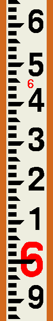
Rod
-
A rod is essentially a stick with precise markings on it. A variety of
rods are available, which have specialized markings for various tasks.
Refer to a surveying text for more detail.
-
The most commonly used rod is the Philadelphia rod, which is marked
in feet, tenths, and hundredths. With care, and a vernier attachment, readings
can be obtained to the thousandth of a foot. Feet are typically marked
with large, red numerals, with tenths marked with smaller, black numerals.
Each bar is 0.01 ft wide. The longer sides of the pointed bars mark multiples
of 0.05 ft.
-
The rod may be marked on both sides - with scales in opposite directions.
Make sure you are looking at the correct side for the type of reading you
want to make.
-
Rods usually have two or more sections so that they can be shortened for
ease of handling and transport. When using the rod in an extended position,
make sure the extension is fully extended and locked into place (or you
may get some peculiar readings).
-
Section of a Philadelphia Rod:
-
For very precise work, special rods are available. These have the scales
marked on invar strips. (See Tapes/Taping for more
detail about invar.) Precision rods are equipped with bubble levels and
braces to help hold the rod plumb and steady.
-
-
-
Sideshot or Intermediate Foresight
-
A shot onto an unknown point which is not a station on the traverse.
Sideshots (or intermediate foresights) are booked in the same way as regular
foresights onto traverse stations, but are not included in the calculations
for vertical error of closure.
-
Sketch
-
A good sketch is invaluable. It will help to explain the job and show the
orientations of various important features. It is definitely worth taking
a few minutes to produce a good sketch.
When you arrive at the job site, size up the whole thing. How is the
job situated with respect to permanent features in the area (roads, buildings,
streams, fences, trees, etc.)? Begin by noting the permanent (or nearly
so) features around the perimeter (and within) the job site. Drawing these
provides a "frame" for the rest of the sketch. Then draw in the
details of the job site. If greater detail is needed than can be shown
at that scale, use auxiliary sketches (on following pages, if necessary)
to get the important features recorded.
(Preserving the approximate scale helps to communicate relative orientations,
but it is not an absolute requirement. Distortions in portions of a sketch
can illuminate helpful details. Whether or not you use an auxiliary sketch
is a judgement call on your part. Which will provide the clearer picture?)
Always make the sketch with North at (or near) the top (or left
side) of the page. Put an arrow with an "N" on the sketch to indicate North.
Include the scale of the drawing. Be reasonably precise.
 Since every survey job involves
a sequence of measurements, you must indicate what you use for reference
points. THESE ARE IMPORTANT! The survey is worthless if it cannot be repeated,
and it cannot be repeated if the reference points are not identified explicitly!
Detailed descriptions of each reference point must be included with the
sketch.
Since every survey job involves
a sequence of measurements, you must indicate what you use for reference
points. THESE ARE IMPORTANT! The survey is worthless if it cannot be repeated,
and it cannot be repeated if the reference points are not identified explicitly!
Detailed descriptions of each reference point must be included with the
sketch.
How detailed? The description must contain enough information
that someone else, who is not at all familiar with the site,
could locate the exact points with relative ease. Since many of the measurements
will be made to the hundredth (or even thousandth) of a foot, the descriptions
must be very clear. There is no room for ambiguity!
One advantage of doing a proper sketch is that it forces you to
look at the whole job before you start taking measurements. Looking over
the job site, you will be able to plan your survey to make the strongest
set of measurements with the least amount of effort. A few minutes invested
up front can save a lot of time later on.
-
Stadia Tables
-
Stadia tables are compilations of the solutions of the equations for inclined
stadia. With the vertical angle reading, one can enter the table and find
factors which are multiplied by the rod interval (difference in readings
between the upper and lower cross-hairs) to obtain the horizontal distance
and elevation difference between the instrument and the rod. A table (with
very small type) can be viewed/printed from here.
-
Staking
-
The placement of markers on a site to identify certain locations (such
as the corners of a building, the right-of-way of a road, the extent of
the slope faces of a dam, etc.) with corresponding information (such as
cut or fill for earthmoving) is the process of staking out a project. It
is the transferal of information from the plan to the actual site --- in
a manner that the work crews will understand and use. It is therefore very
important that the information be as simple and as clear as possible.
-
There are many conventions and methods for staking and marking. The particular
practice will depend on the type of job and the type of information that
must be communicated.
-
Staking must often be done several times during a project as various phases
of the work will "erase" these temporary markers.
-
Stations
-
The term station refers to a point on a baseline that is at a known
distance from a starting/reference point. The starting point is usually
referenced as 0 + 00, but there are occasions where another value
might be assigned. It is generally desirable to have all stations noted
by positive numbers, since negative stations often lead to confusion of
interpretation. Full stations are at integer multiples of some base
distance - usually 100 feet or 100 meters. The numeral to the left of the
"+" indicates the multiples of the base distance and the numeral on the
right indicates numbers less than the base distance.
-
For example, if the starting point was designated 0+00, a point
375.62 feet away (following the baseline) would be noted as 3+75.62.
-
The term "station" is also used more loosely to indicate any point used
in a survey, such as benchmarks and turning points. As in so many aspects
of language, context is important.
-
Tapes/Taping
-
A tape is a flexible device used for measuring linear distances. There
are tapes made of many materials, such as cloth, kevlar, steel, and invar.
The most common tape used by surveyors is the steel tape. Standard lengths
are 100 feet (for English unit surveys) or 30 meters (for SI unit surveys).
-
Tapes are usually marked at every foot or meter. At the ends of the tape,
there will be finer divisions (tenths/hundredths of a foot, or decimeters/centimeters).
Tapes are called "add" tapes if the finer divisions are in a major unit
beyond
the ends of the regular length, e.g., beyond the zero and 100-ft marks
of an English tape. If, on the other hand, the divisions are marked inside
the last major units, the tape is called a "cut" tape. E.g., the decimeter/centimeter
divisions are marked between the zero and one-meter marks and between the
ninety-nine and one hundred meter marks.
-
For high precision surveys, invar tapes are useful. Invar
is a nickel-steel alloy that has a coefficient of thermal expansion of
2.0x10⁻⁷ to 5.5x10⁻⁷ per °Fahrenheit. Regular
steel tapes have a coefficient of thermal expansion of 64.5x10⁻⁷
per °Fahrenheit, or 116x10-7 per °Celsius.
-
Traverse
-
A traverse is a series of consecutive line segments whose lengths
and directions are determined by field measurements. A closed traverse
either closes back upon its starting point, or begins and ends on stations
of known positions. An open traverse does not close on either itself
or a station of known position. As such, an open traverse does not provide
any means for checking for errors and mistakes. Open traverses should generally
be avoided. If an open traverse must be used, the procedure should be repeated
to provide a check of accuracy.
-
Turning Point
-
A turning point is a station, either temporary or permanent, that
is used as a pivot between sequential instrument positions. Since a turning
point is used to extend the primary survey, its elevation must be precisely
recoverable (at least for the time it takes to move the instrument and
take a backsight on it). A spot on rough ground (e.g., a plowed field)
is unacceptable. A mark on pavement, a rock face, top of a fence post or
fire hydrant would be good. Surveyors will often carry stakes that can
be driven into the ground to provide a temporary solid surface for a turning
point.
-
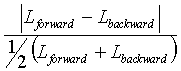
Vertical Error of Closure
-
The error of closure of a leveling survey refers to the cumulative error
of the entire circuit. If a circuit is run from a point of known (or assumed)
elevation back to that point, then the starting elevation and the ending
elevation should be the same. In actual practice, errors are made
in measurements that result in a discrepancy between the two values. That
discrepancy, expressed as a raw vertical distance (in units such as feet
or meters), is the error.
-
The allowable error in any such survey depends on the level of accuracy
required for the job. Various levels are accuracy are required for different
orders
of surveys.
-
Zenith
-
The zenith is that point of the celestial sphere that is directly overhead
from the observer. For a transit or theodolite, it is the point directly
above the vertical axis of the instrument. (Compare to nadir.)
-
-
Back
-