INTRODUCTION
TO THE US RECTANGULAR SURVEY SYSTEM
Introduction
The
Public Land Survey System was one of the most extensive mapping projects
ever undertaken in the U.S.The
principle was to measure all of the land in the public domain prior to
its sale to the public.It provides
a systematic and orderly description of real property.Since
it only encompasses land that were a part of the public domain, not all
of the country is included.States
along the Atlantic seaboard, from Georgia to Maine, along with Kentucky,
Tennessee, West Virginia, Pennsylvania, Texas and Hawaii are all states
that can be classified and metes and bounds states.This
distinction will be made clearer later.
History
The
Revolutionary War left this new country with several problems.First,
there was a strong sense by the citizens that there should be a weak federal
government with a strong state government.But
this left some states rich in land while others were closed to further
extension of their boundaries.In
addition, the federal coffers were empty and soldiers who fought for independence
were beginning to demand compensation.In
forming the United States of America, the federal government won an important
concession from some of the states.Those
that claimed lands west of the Appalachian Mountains were asked to given
those lands to the federal government who would then sell off that land
to the citizens.


Metes
and bounds refers to the quilt-like nature that real property in the original
colonies was described.It was common
for the first settlers to describe the best lands available and purchase
only those lands useful for farming.This
left the poorer land to subsequent settlers who had a hard time clearing
and making the land productive.An
example of this kind of land division is given in figure 5-1.
There
were several proposals on how to subdivide the lands in the public domain.The
final plan involved the subdivision of the land into townships and then
into sections and further into aliquot parts.The
first site where this new method of subdivision was initiated was in Ohio,
abutting the Ohio-Pennsylvania line.This
was called the Seven Ranges since it consisted of seven tiers of townships
running west of the state line.Ohio
is often referred to as the testing ground for the Public Land Survey System
(PLSS) since it contains at least 20 different and distinct systems.Some,
like the Virginia Military District, followed the metes and bounds survey
system of the colonies while others, like the Unites States Military District,
were modifications of PLSS.

 The
rectangular survey system devised for the PLSS is often credited to Thomas
Jefferson.It is known that Jefferson
proposed a rectangular survey system, although his system was based on
the decimal system -- townships 10 miles by 10 miles.This
was modified to the present-day size of 6 miles by 6 miles.The
Ordinance of 1785 marked the beginning of the PLSS.Thomas
Hutchins was the Geographer of the United States and directed the survey
of the Seven Ranges.The early surveyors
had to face a lot of adversity.For
example, because of an Indian attack, only four miles of survey was run
by Hutchins during the first year.
The
rectangular survey system devised for the PLSS is often credited to Thomas
Jefferson.It is known that Jefferson
proposed a rectangular survey system, although his system was based on
the decimal system -- townships 10 miles by 10 miles.This
was modified to the present-day size of 6 miles by 6 miles.The
Ordinance of 1785 marked the beginning of the PLSS.Thomas
Hutchins was the Geographer of the United States and directed the survey
of the Seven Ranges.The early surveyors
had to face a lot of adversity.For
example, because of an Indian attack, only four miles of survey was run
by Hutchins during the first year.
Public
Land Survey System
Townships,
as was described earlier, are six miles square (see figure 5-2).They
are numbered north and south from a base line (called townships) and east
and west of a meridian (referred to as ranges).Therefore,
the first township to the north and east of the initial point (origin of
survey) is T1N R1E - township 1 north, range 1 east.The
meridian is suppose to be a true north-south line and base lines are run
due east and west.The origin (or
principal point) is the intersection of the two lines.Before
establishing townships, the base lines and meridians were to be surveyed.The
surveyor was to measure along the base line, setting the appropriate corners.At
the end of 6 miles, the township corner was established.The
surveyor would then continue with the survey.The
north-south township lines were run true north.It
was quickly realized that problems will occur due to convergence of the
meridians.Recall from geography,
lines of latitude and longitude are used to identify the position of points
on the ground.Longitude lines run
from the North to South poles.They
also converge at these poles (see figure 5-3).Because
of that, the distance between these meridional lines will get shorter the
closer we get to the poles.In case
of the PLSS, this means that the distance along the top of the township
will not be 6 miles long, but something shorter.

Because
of this problem, later instructions to the surveyors were to include survey
of correction lines.The idea now
is to divide the land into 24-mile tracts. This represents four townships
on a side with guide meridians along the sides running north-south and
correction lines or standard parallels running east and west (figure 5-4).These
correction lines allowed the surveyor to adjust for the convergence and
other errors in the surveys.
Townships
are further subdivided into sections, each of which is 80 chains (one mile)
on a side (figure 5-5).They are
numbered starting in the upper-right hand corner and increase going back
and forth through the township.Sections
can then be broken into aliquot parts as shown in figure 5-6.It
is usually not convenient to break sections down below the level of 40
acres (quarter-quarter section).A
section contains 640 acres.The filled
circles in figure 5-6 indicate the actual corners set in the field by the
surveyor.Note that the center of
the section was not established by the government surveyor.The
center is defined by the intersection of lined joining opposite quarter-corners.The
issue of where the center of section is under a lot of debate since county
surveyors often set the center after the government surveyors completed
the survey of the section.Those
corners may control property, even though they are not at the intersection
of the opposite quarter-corners.

Figure 5- 4.Correction
lines to the public land survey system.

Figure 5- 5.Subdivision
of township into sections.
How
the original surveyors surveyed the land

Figure 5- 6.Subdivision of a section.
There
is a hierarchical structure to the Public Land Survey System.Townships
were run first followed by sections.While
running townships, Guide Meridians and Standard Parallels were also established.This
is important because when a corner is lost, the surveyor must work down
this hierarchical structure in order to replace the lost corner.Therefore,
township corners have more importance than sections corners which have
more significance than quarter corners.
Lines
run by the surveyors were done using a compass and chain.The
Gunther chainhad a length of 66
and was comprised of 100 links, each of which was 0.66 long.Chains
were heavy, bulkyand difficult to
handle.They were usually dragged
along the ground during the survey.Length
errors due to slope, kinks, bad alignment and other problems were present.Some
chains were intentionally made too long to compensate for the errors in
taping.Half -chains were common
during the early surveys because they were easier to handle.Other
chain lengths were also used by different surveyors.
Line
of sight was done by compass equipped with a sighting mechanism.The
surveyors were to note the deviation of the needle and compensate for this
magnetic declination.Magnetic north
is constantly moving and in many places is not the north direction.The
deviation between the magnetic north and true north is called the magnetic
declination.When trees were on line,
they were blazed with identification and the compass was moved to the other
side of the obstruction.
These
errors in sighting and measurement led to the improper placement of monuments
set into the ground.As newer instrumentation
became available, the surveyor began to survey more accurately and faster.To
correct all of the corners that were set in error would wreak havoc on
our land system.Therefore, the courts
held very early that the location of the monuments as set in the ground
by the original surveyors were correct, regardless of whether they were
in their correct theoretical position or not.For
a government survey to be valid, the official plat must have been approved
by the government land office.There
are a couple of exceptions such as fraud and mistakes that can be corrected
later.
It
is important to restate that the PLSS surveys are conclusive and binding
upon all parties.An erroneous survey
cannot be corrected by a private individual.If
a mistake was found or fraud was used in the laying out of the survey plat,
only the federal government can take corrective action.Nor
can the courts correct errors found in the surveys.The
list of court cases that substantiate these principles are long.The
courts state that it is the monuments and plat of survey that dictate the
location of property, not the description.
Hardships
in surveying the public domain
While
there are some who would say that the original surveys were very sloppily
laid out, one needs to consider both the state-of-the art in surveying
technology at that time and the conditions in which the surveys were performed.Each
survey was given a set of instructions on how to perform the survey.The
surveyor then needed to find helpers and purchase all of the supplies that
would last through the survey season.The
American landscape was full of original-growth timber that was very dense
in certain areas.Mosquitoes and
other insects were rampant and hindered the survey crews along the way.Early
snowfall sometimes marooned the survey crew in the field and they had to
fend for themselves for survival.
A
big problem was the Indians who knew that these surveys were an intrusion
onto their land.They would disrupt
the surveys anyway they could, including attacking the survey parties.The
city of Battle Creek, Michigan, is named after an attack by the Indians
on a survey party in the lower part of the state.Given
all of the adversity, it is a wonder that the resultant surveys were as
good as they are.
Marking
corners, witness corners
The
original corners were marked with whatever markers that were available
to the surveyor in the field.In
areas were there were woods, wooden stakes were placed in the ground at
the location of the corner.Witness
trees were marked and noted in the field notes.In
the prairies and other areas which were lacking trees, pits were excavated
and stone mounds were constructed (if stones were available, otherwise
the soil was used as the mound).The
problem is that the wooden stakes were subject to decay.Woods
were cleared for their lumber.Mounds
became flattened by the natural forces of nature.It
was not until 1908 that congress authorized the purchase of metal monuments
to mark the location of corners.
After
years of neglect, evidence of the location of corners becomes difficult
to find.This causes problems since
property in the public domain is described with respect to those government
corners.It is the job of the surveyor
to evaluate all of the evidence in order to re-establish the position of
the corner.Unfortunately, a lot
of this evidence is contradictory.More
of this will be discussed in the lesson on boundary surveys.
Fractional
sections
Not
all sections (or townships) are considered regular.A
good example of this is if a lake or river was located on the land.Thus,
the section did not contain a full nominal 640 acres.It
should also be pointed out that once a territory became a part of the public
domain, this did not necessarily mean that all of the lands within the
territory were subject to government surveys. There
may have been individuals who already owned land from another sovereignty,
such as the French or Spanish.Once
the land became a part of the U.S. the rights that these individuals had
in the real property were maintained.Therefore,
private claims also created fractional sections.Indian
reservations were also not considered a part of the public domain but were
lands belonging to a particular Indian tribe.There
are some exceptions, most notably the Alaskan Eskimos whose lands were
to be surveyed.There are also a
number of other situations where complete sections were not possible.
Two
examples of fractional section are shown in figure 5-7.The
red lines indicate where the government lines (section lines and 1/4 lines)
would fall if the section were a full section.Situations
like this cause a lot of problems for the surveyor, particularly the case
shown on the left.

Figure 5- 7.Examples
of fractional sections.
Excess
and deficiency
Because
of the different problems encountered in the subdivision of a township,
errors will creep into the locations of the corners.The
general rule is that all excess and deficiency will be placed in the north
and west of the township.Figure
5-8 shows how the excess and deficiency is allotted to section 6 which
is located in the northwest corner of the township.Notice
that on the excess and deficiency is placed in the last quarter-quarter
of the section.If this was further
broken down into quarters, then the excess/deficiency would be place in
that northern most quarter-quarter-quarter of the section.The
same applies to the western side of the section.
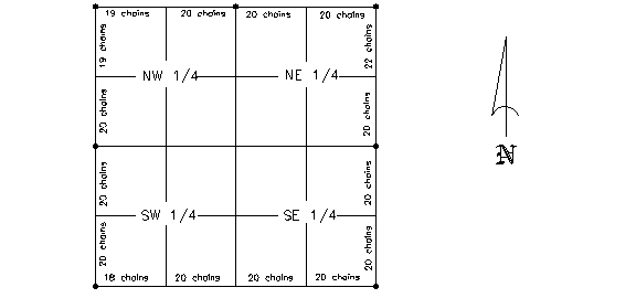
Figure 5- 8.Distribution
of excess and deficiency in section 6.
Retracement
surveys
The
PLSS is a hierarchical survey system.Township
corners and lines have precedence over section corners and lines.In
addition, before a monument can be classified as being lost, all evidence
of its location must also be lost.This
is not as simple as it appears.For
example, an old maple tree may have been used as a witness tree and there
could be remnants of the old trunk near an indentation on the ground.Is
this the original bearing tree or another tree of the same species?The
surveyor needs to be part detective of separate all of the facts.Declaring
a corner lost is the last resort.
Review
Questions
1.Describe
the difference between a metes and bounds state with one under the PLSS.
2.Describe
the purpose of guide meridians and standard parallels and their use in
the PLSS.
3.An
acre consists of 43,560 square feet.If
a piece of property is one chain wide, how long must the other side be
in order to contain exactly one acre?
4.Explain
why it is important that the monuments set by the original surveyor are
conclusive on all parties.Give
an example.
5.Why
is a survey in the PLSS difficult today when all of the sections corners
and quarter-corners were set back in 1839?Explain.
6.How many acres are contained in section 6 as shown in figure 5-8?