The Recording of the College Premises
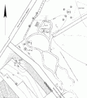 |
To have a planning basis in order for the "agenda park", in the year 2000 the class VT97 got the order to make a location and elevation recording of the northeast college grounds. |
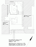 |
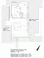
In order to have
a planning basis for the reconfiguration of the schoolyard of the "Vocational
College of Further Education I Stade", the class VT01
got the order to record the existing schoolyard topography in the
year 2002.
Therefore the students of the class were divided into four groups who conducted the recording of different parts of the schoolyard. They described their work in "group reports", which can be reached by the links. |
| southern part of
the lower schoolyard including the entrance stair
northern part of the schoolyard including ramp and stairs in front of BBS II upper schoolyard |
|
 |
An aim of the reconfiguration of the schoolyard is that the ramp between the upper and lower part of the schoolyard must have a downward gradient permissible for wheelchair users (max. 6 %). For the determination of the necessary ramp length, the elevation of the schoolyard was determined by the class VT99 in the year 2002 with loop levellings, which are attached to an elevation benchmark. |
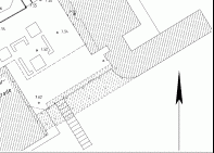 |
Class VT99 (polar method from street) and class VT01 (off-setting form school yard) deterimined the location of the new building block and integrated it into the exististing digital map. | 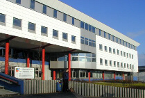 |
| The complete engineering plan of the recordings of 2000 and 2002 looks like that ... | 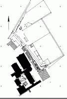 |
Back